

The island of Vaeroy - a part of Lofoten Islands - was our first stop in this indescribable archipelago. Because of the warm waters of the Gulf Stream, although located within the Arctic Circle, Lofoten's climate is pretty mild. And Vaeroy, detached from the other, tightly squeezed islands and completely surrounded by the sea, is even warmer - snow rarely stays on the ground for long. It's unbelievable how beautiful and diverse the island is considering its tiny size. It has everything - a cozy town, the mountains, cliffs and paradise beaches - it's a tiny, concentrated mini version of the entire Lofoten archipelago - a perfect starter before exploring the rest of it.
How to get to Vaeroy (and Lofoten)
There are several ways to reach Lofoten. Although Norway is known to be expensive, getting there will not break the bank. And, to see one of the most beautiful archipelagos in the world - it's definitely worth the price!
There are extremely cheap flights available to Oslo from all over Europe, and then from Oslo, you need to fly up to the north - places like Narvik or Bodo. When you're there, the best thing to do is to rent a car and either drive from Narvik, or take a ferry from Bodo to Lofoten islands. We chose Bodo.
To be honest, we hadn't planned to visit Vaeroy at all. At first, we had thought about going straight to the most picturesque village in Lofoten - called Reine in Moskenes island and only from there to start exploring the area. But we couldn't find a direct ferry from Bodo that would match our schedule - so we decided to go for the very early morning one - the one which went via Vaeroy to Moskenes - this required a 12-hour layover. It was a great coincidence that we had a chance to set foot on Vaeroy's shores.
Ferry from Bodo to Vaeroy
We stayed one night in Bodo before traveling to Vaeroy, but the town is very ordinary and there's absolutely nothing special about it. The hostel, however, was very nice and quite cheap.
The Bodo-Vaeroy ferry departed before 5 am and it took over 5 hours to reach Vaeroy. The cost for the transport of the rented car and 4 passengers was around 1200 NOK (130 EUR/145 USD) - if you divide it by 4 people, it's only around over 30 EUR/33 USD per person.
The Vaeroy-Moskenes ferry cost around 600 NOK and took only 1 hour.
Here, on this website you can find official the timetables and all ferries available http://lofoten.info/en/Ferry-and-expressboat
The ferry ride was extremely comfortable, the ship was huge and, although it was June, it was quite empty. If you hadn't had a good sleep the night before, you could have comfortably dozed off on the ferry.
Visiting Vaeroy - the town, the beaches and the mountain trails
We spent only 12 hours in Vaeroy - we arrived there at around 10 am and got the next ferry to Moskenes at 10 pm. Although it was such a short time, we managed to see virtually all that's there to see on this tiny island.
The first glimpse from the ferry of the island emerging from the horizon was breathtaking. The amazing views compensated for the capricious weather and strong wind. You can experience snow, rain, blizzard and beautiful sun, all together within... 1 hour in Vaeroy!
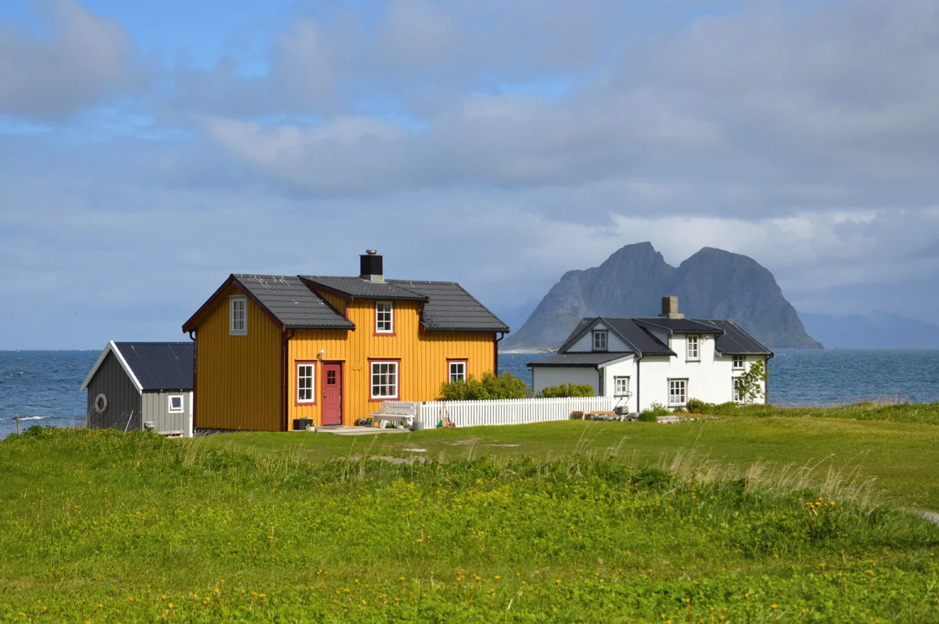
Upon arrival, the beautiful village of Sorland welcomed us with little wooden houses surrounded by the sea and pointy peaks of the mountains. The scenery was truly peaceful, idyllic but very raw and harsh at the same time. Something out of this world.
Below, we pasted the screenshot of google maps as well as the added names and exact locations of the places we visited as it's nearly impossible to find them online on google maps:

The screenshot of the map

Vaeroy seen from the ferry

The village of Sorland

Vaeroy and other Lofoten Islands in the background

Unreal views of the beaches near Breivika

Beautiful beach at Breivika
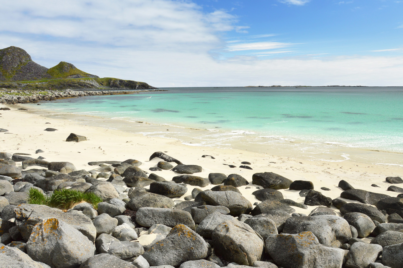
White sand and turquoise sea

Beautiful beach

Spectacular beach at Breivika

On the beach - wearing a t-shirt looks like in a warmer place ;)

Spectacular scenery at Brevika

The beach from the distance

Beautiful sea

Fishermen house
Breivika - Beautiful beach in Vaeroy
As there are practically no tourists in Vaeroy, we decided to just go anywhere and start exploring the island. We drove to the west, through the narrow mountain ridge towards the sea at Breivika (marked 1 and 2 on the map) where a few fishermen's houses stood.
Right away, a spectacular view emerged - the white sand beach (1 on the map) with extremely intense, turquoise color of the sea - something you would see in the Caribbean or other tropical locations. It defied simple logic, as no one associates the Polar Circle with such paradise beaches. If only the weather was a bit hotter... But maybe then, this hidden place would lose its charm and peculiarity.
Going further more, we encountered another, little beach with beautiful local fishermen's houses (2 on the map). Again, the strong color contrasting with the barren mountains and cozy red homes created an original scenery that you can find only in Lofoten. Those little beaches, however, were only a foretaste of what awaited us on the main Lofoten islands.
The best view in Vaeroy - the trail to Mastadfjellet viewpoint
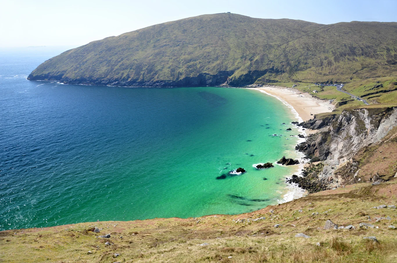
Typing "Vaeroy" in Google, one of the first images that comes up is the magnificent cliff at Mastadfjellet overlooking another white sand, turquoise beach - Punn Sanded. We'd had no idea how to reach this point and it is a must when you're in Vaeroy - don't miss it!
We asked one of the locals for directions and he pointed to the end of the village of Sorland and said that from there we had to hike for around 1 hour 20 minutes (I marked this trail exactly on the map with red dots). It seemed that there was a road all the way up to the edge and the viewpoint, but we saw a sign saying "not allowed to drive" so we didn't risk and just started walking.
The trail at first is narrow and steep, but then it joins the paved road and overall is extremely easy. However, the weather can be annoying - the wind is extremely strong and usually comes with drizzle and fog. Even in June, it was pretty cold and wet (Vaeroy may be the warmest place in the Arctic Circle, but it's not warm in normal standards). Make sure you wear proper footwear as the ground is muddy and slippery in places.
Don't walk the entire trail to the very end at once - get off the path and admire unbelievably wonderful views of the entire Sorland and the beach at Sorlandshagen (around number 3 on the map) - there's no signs or trails there - you just must walk on grass but you won't regret it!
When we finally reached the end of the trail to the viewpoint (number 4 on the map, you'll see the antennas on top), we thought it couldn't get better, and then, we saw the Punn Sanden white sand beach and the Mastadfjellet mountain. I'm not going to joke, but for me, it was one of the most amazing and breathtaking views I've ever seen.
You can also walk around the Mastadfjellet mountain - from the village of Nordland, past the runway and along the coast. It's impossible, however, to get to the Punn Sanden beach itself from the land.
Nordland and Sorland
Tired after the hike, we went to one of the few cafes in Sorland to have lunch and chatted with the locals. We had not seen any tourists besides us in Vaeroy.
A walk around Sorland is very pleasant - this little village with its mild climate is perfect for producing fish which is imported mainly to Spain and Italy. You can see it everywhere - the fish hanging and drying can be spotted all over Sorland.
In the afternoon, we went towards Breivika beaches again to enjoy the amazing views and then further on to Nordland (5 on the map) - a tiny settlement composed of a few houses and a beautiful wooden church. From there, you can easily have a wonderful view over the rest Lofoten islands in the distance - especially spectacular late in the evening during the summer when the sun never sets. To see posts about more places in Lofoten, click here.

Sorland seen from the trail to Mastadfjellet viewpoint
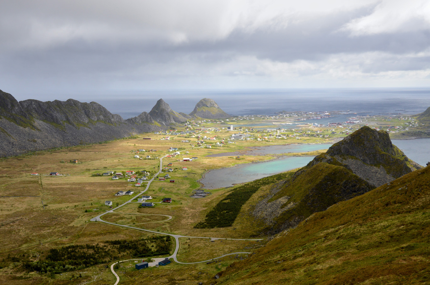
View from the trail

Beach at Sorlandshagen

The beach at Sorlandshagen seen from the trail

The viewpoint and breathtaking scenery

The Punn Sanden beach

Another view of Punn Sanden beach

Punn Sanden beach seen from the viewpoint

At 10 pm in Sorland

Dramatic landscapes in Nordland

Local house in Nordland
Houses in Nordland

Wooden church in Nordland

Seagulls have nests everywhere

Hundreds of fish in Sorland

After 10 pm the sun is still shining
Related Posts


Copying without permission is not allowed. If you wish to use any of the site's content (photos or text) or work with us, please contact us.
We welcome questions, advice, support or criticism. However, spam comments will be removed.